Photos

“The picture was taken from Boundary Street looking north on Shattuck Rd. prior to the construction of the Beaverton-Hillsdale Hwy. On the west side of Shattuck, about 2/3 of the way up the hill past the creek, you can see the old Fairvale School and just north of that the grocery store, facing east on the corner of Shattuck & Hess Rd. (now Hamilton Street) …. When the highway was constructed, the grocery store was put on skids and pulled by a team of 4 horses down the hill to a new location. In the 1950's the Albertson chain bought the property, tore down the old store, and built a "supermarket". There is a picture of the old store in its "highway location" on the wall behind where the grocery carts are kept at the current Albertsons.”
Shattuck Road as seen from a bit south of Beaverton-Hillsdale Highway as it looked in the 1890's (photo #26860 by permission of the Oregon Historical Society). The white building at left with two outhouses along the back fence is Fairvale School (see below), and just above it is the Fairvale Store (see below). Peeking out from the trees to the right of the store is the Tigard/Rogers House (see below) at the corner of SW Hamilton Street (called Hess Road back then) and Shattuck Road, which still stands today.

Beaverton-Hillsdale Highway and Shattuck Road, as seen from a bit south of Beaverton-Hillsdale Highway and west of Shattuck, probably taken in the 1920's. Photo uncredited. Beaverton-Hilldale Highway runs diagonally from mid right edge to lower left corner, and Shattuck runs from approximately mid left hand edge to lower right corner. The Farivale School is the white building near the left edge center of the photo. The Fairvale Grocery Store has moved down to the corner of Shattuck and what is now Beaverton-Hillsdale Hwy (just to the lower right of the center of the photo).
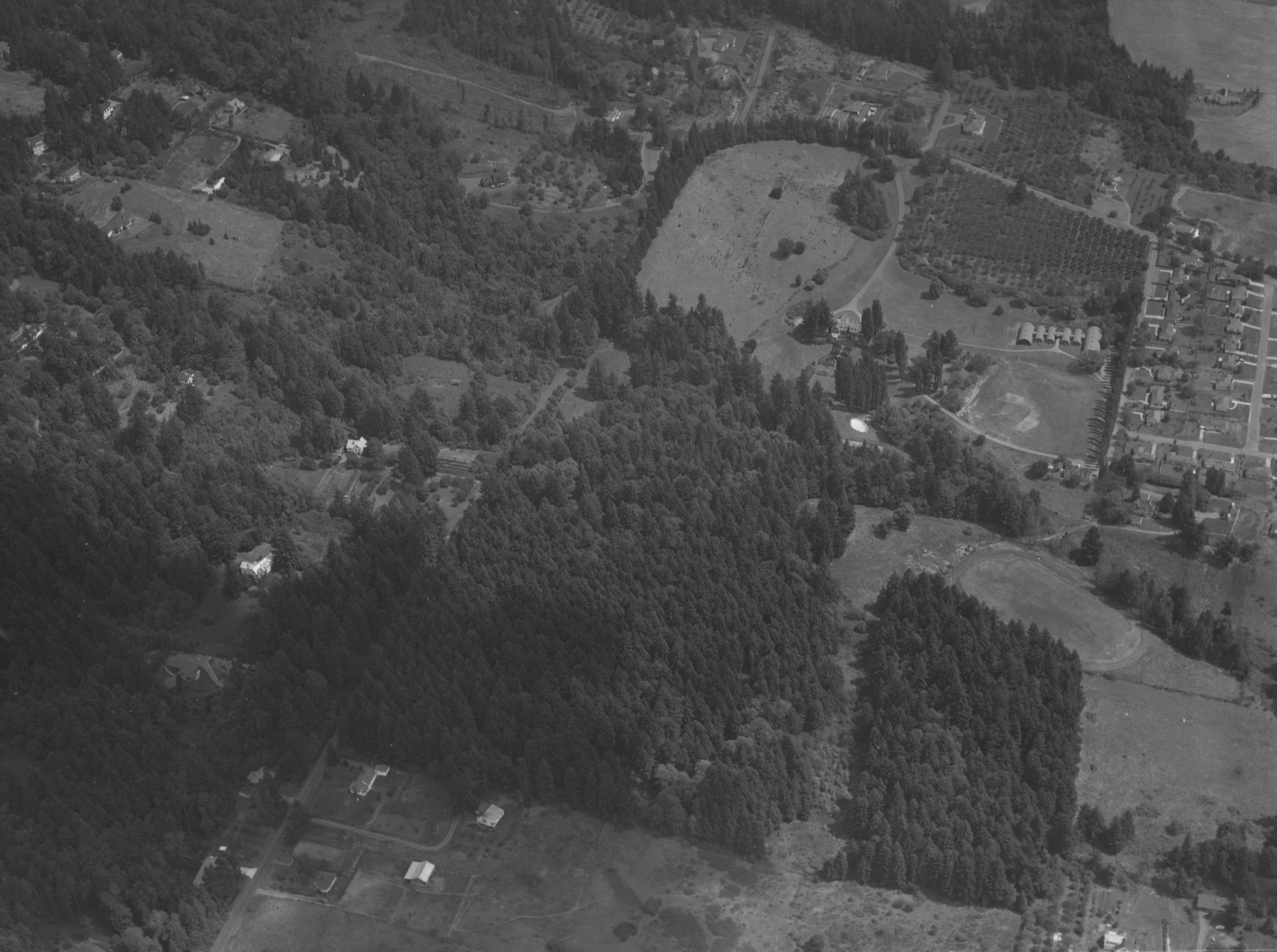
1954 Aerial view of area near SW Patton Road, looking east toward Shattuck Road. Record date: 12/31/1954. The house at the end of the long drive in the upper center is the Wilcox mansion, used at this time as Columbia Prep School. The houses to the right are along Thomas and Lowell streets. To download the photo, go to: https://efiles.portlandoregon.gov/record/4105891
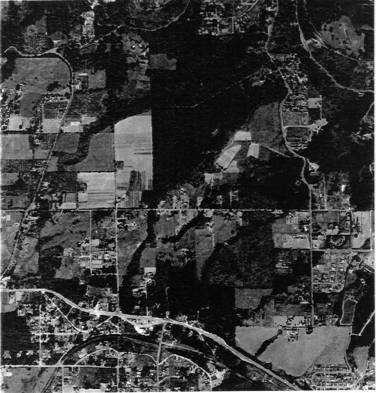
1945 Aerial View of Upper Fanno Creek Watershed. North is to the top. Council Crest is in the upper right-hand corner. Fanno Creek flows along the Beaverton-Hillsdale Hwy in the lower one-third of the photo. Note the residual forest along several upper tributaries. (Oregon Historical Society; cropped from U.S.C.G.S photo #487, OrHi 100889)
1943 Aerial view of SW Portland in the Southwest Hills area. Includes Bridlemile, Hayhurst, Raleigh Hills, and Healy Heights Neighborhoods. Also visible are Washington Park, Marquam Hill, Council Crest Park, Hillsdale Park, Gabriel Park, April Hill Park, Hideaway Park, Raleigh Park, Raleighwood Park, Water Reservoirs 3 and 4, and Multnomah Stadium. Map is intersected east to west by Beaverton-Hillsdale Hwy (Hwy 10) and Sunset Hwy (I26). Also visible are SW Canyon Rd, SW Scholls Ferry Rd, W Burnside Rd, and SW Capitol Hwy. To download the photo, go to: https://efiles.portlandoregon.gov/Record/3891176/

Buildings

The Fairvale Store (1909), at the corner of SW Beaverton-Hillsdale Highway and SW Shattuck Road. Photo courtesy of Evelyn Rogers used with permission from the Multnomah Historical Association.
In 1955 Mrs. Rogers sold it to Albertsons.

The two-room Fairvale School (1891 - 1928) was located near the intersection of SW Shattuck Road and SW 53rd Street.

The Tigard/Rogers House (1850’s) , 4504 SW Shattuck (corner of SW Shattuck and SW Hamilton Street). Rogers' Family Photo.

Tigard/Rogers House. Photo by Victor von Salza (2004).
The Tigard/Rogers House was built in 1853 or 1854 by Andrew Tigard, who had the Donation Land Claim for this land. The house was sold to Edward and Esther Rogers in 1875. The Rogers farmed here for many years. In more recent years, Roger Hancock, great-grandson of Edward and Esther Rogers, owned the house from 1981 until he died in 2022.

Tigard-Rogers House and its Heritage Tree (12/28/2022). Photo by Mark Barnett


Until late 2022, the site included a collection of antique steam engines, including a ~1903 tractor. Photos by Mark Barnett
Of related interest:
PDF download from Oregon Archaeological Services at:
http://heritagedata.prd.state.or.us/historic/index.cfm?do=main.loadFile&load=55242.pdf
Oregonian article “Tigard/Rogers house in SW Portland looking more and more like Portland's oldest” at: https://www.oregonlive.com/history/2014/12/tigardrogers_house_in_sw_portl.html

The Long House, 4402 SW Shattuck. Photo by Victor von Salza.
Richard and Delores Long bought the house in 1943 and lived it into the 1970's.

Wilcox Manor 3707 SW 52nd Place
(turn north off Windsor Court). Photo by Victor von Salza.
The Wilcox Estate (3707 SW 52nd Place) was the country home of Theodore B. Wilcox, a banker and major player in the China flour trade in Portland from 1884-1918. The estate, called Glenwood Farms, was designed in the Colonial Revival style by architect Kirtland Kelsey Cutter and completed in 1917.
When Wilcox died in 1918 the estate was given to his son, Theodore Burney Jr. (Ted), who lived in the home until 1948. They sold the property, now known as Wilcox Manor, to the Order of the Holy Cross for use as a school. The Columbia Preparatory School was a private Catholic High School for boys until 1955 when it was sold to land developer, Robert Strahorn, who subdivided the 160 acres into hundreds of lots. The estate came into the hands of John and Ruth Powell who were associated with Strahorn. A Mr. Ballentine owned the property next and remodeled the Manor into eight apartments. In 1965 Ken Guenther purchased it, and had it placed it on the National Register of Historic Places in 1993. As part of the requirements for being on the National Register of Historic Places it is open for public viewing once a year. Currently Wilcox Estates is a condominium complex.
Of related interest:
• Theodore B. Wilcox, Captain of Industry and Magnate of the China Flour Trade, 1884-1918.
• Classic Houses of Portland 1850-1950 William J. Hawkins III and William F. Willingham
• The Southwest Community Connection, April 1996
• The Oregonian September 1997
• The Southwest Connection August 2007 Wilcox Manor opens its doors to neighbors" by Jessie Kirk

Wilcox Manor Gardens designed by L.M. Thielsen. Photo by Chris Kahle.
The Walther House.
When Wendy Squires and Angel Lopez owned (1998-2010) the house known in Bridlemile as the Walther House at 4021 SW 45th Avenue, Angel and Isabel Lopez gave Ginger Danzer a tour of their home. Fred and Rosa Walthers built the house in 1948. The architect was Ericson. The signature feature the houses Ericson built in Portland are wagon wheel windows. The one in the Walther home is in the guest bathroom. Half the wagon wheel turns to open the window.
Originally 50 acres surrounded the home. Beautiful old trees fill the 0.9 acre property. Angel Lopez was told that Mr. Walthers may have been from the south because many of the trees he planted are magnolias and dogwoods, trees typically found in the southern part of the US. There are 51 trees on the property. A circular drive forms the approach to the house. On the north side of the drive, a steep down slope section leads to the garage. A small building that resembles a playhouse also on the house on the north is the well house. A well still supplies water to the gardens. It probably provided water to the house before electricity was installed.

1852 Donation Land Claims Map

Section 17 of the map has the name of Albert Kelly, the first non-Indian land holder in Bridlemile. South of that, in section 20, is the name of Thomas Tice, the original land holder of Multnomah Village. To the east, in sections 15 and 16, is the name of James Terwilliger.
In 1850, the US Congress passed the Donation Land Claim Act of 1850 to promote homestead settlements in the Oregon Territory.
Miscellaneous
In the 1850's H. M. Humphrey, John Talbot, Albert Kelly and Peter Smith were Donation Land Claim holders in our neighborhood.
The Red Electric Railroad, Southern Pacific’s Oregon Interurban, ran just south of Bridlemile. That is it was just south of the current Beaverton-Hillsdale Highway. The railroad was built in 1871 and ran until the mid 1920’s..
The Crawford family was located in what is now the Montmore sub-division in northern Bridlemile. They had a saw milll on SW Tunnelwood Street, about where 40th would be.
An apple tree from Albert Kelly’s 1850 orchard is in Hillsdale. To learn more about the tree and its current location, click here. If the link doesn’t work, go to: https://oregontic.com/oregon-heritage-trees/dosch-yellow-bellflower-apple/
From: “Southwest Hills Resource Protection Plan” by the Portland Bureau of Planning, May 1992.
https://www.portlandoregon.gov/bps/article/59062
P. 13:
“Area History
Human settlement of the Southwest Hills began approximately 10,000 years ago. The Chinook tribes lived in the Lower Columbia, which included the Tualatin Mountains (Portland West Hills) as it was known to the Native Americans (Hummel et al. 1983).
The Chinook tribes consisted of approximately 12 smaller tribes including the Clatsop, Multnomah, Clackamas and Wasco. The various tribes were distinguished from one another by dialect and in some cases cultural differences. The base of Chinookan social organization was large, permanent and independent villages linked together by trade and marriage alliances. Social organization was also stratified by wealth and heredity.
At Europeans settled in Portland, the West Hills were chosen as home sites because of the terrain’s beauty and outstanding views over the Willamette and Tualatin Valleys (Bureau of Planning 1977). Land claims were made through the Federal Land Donation Act of 1850, a homestead act, which allowed for claims of up to 640 acres. Several persons made claims on lands in Southwest Portland who are remembered through street names, including, P.A. Marquam, James Terwilliger and H.M. Humphrey.
Development int he Southwest Hills has continued ever since. Home building proceeded slowly as builders contended with the area’s steep slopes and frequent landslides. Development picked up in the 1920’s with the use of terracing and grading in building homes. It was during this time that public development took place as well. The Oregon Health Sciences University and Duniway Park were developed in the 1920’s. Council Crest Park was completed in the late 1930’s. Since the 1920’s development in the Southwest Hills has continued at a steady pace.”